
If you are active on HF or non-repeater VHF/UHF frequencies, you should know your operational grid square when making contacts. Many hams need to know your exact location for logging and awards purposes. The grid square system was adopted by the IARU for specifying amateur radio station location in a relatively small area.

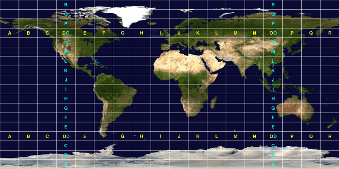
The planet is divided up into 32,400 grid squares roughly 100mi wide by 70mi high (in continental USA) per the Maidenhead Locator System. More detail here.
Basically, our planet is divided into 18×18=324 fields identified by two letters (AA-RR)
Each field is 20° longitude (east-west) and and 10° latitude (north-south). The first letter represents longitude and the second latitude as shown below.
Each field is sub-divided into 10×10=100 squares starting again in the southwest counting north in columns of tens and shifting east for the next ten.
If you look carefully at field IO above (encompassing most of the UK and Ireland), you can see this refined grid. It looks like this in a more geodetic (less flat) view:
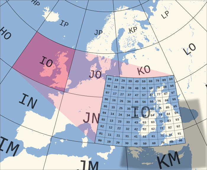
Here you can clearly see square 00, lower left and 99, upper right with the other 98 squares everywhere in between.
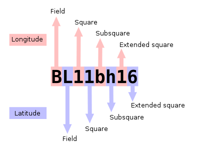
This combination of field plus square gives us the basic grid square system. It follows the specific format as shown below.
Of interest to most readers of this site, the continental United States (CONUS) is dominated by fields DN, EN, DM, and EM, and encompasses 488 grid squares, including little strips of land that overlap a square. Several are rare contacts with few active hams located there.

So the first four digits are the basic grid square. The grid square can be further refined into smaller chunks of sub-squares (roughly 4×3 miles) and even extended squares (tiny; not relevant to ham radio).
For most radio amateur purposes, the basic four-digit grid square is adequate. Sub-squares are generally useful only for UHF and microwave contacts where more precise location is required, and are normally lower case alpha characters.
Your grid square locator should be on any digital mode computer apps used for communication so that other stations know your location (QTH). It’s also a good thing to include on your QSL card if you send one.
To determine your grid square, look at your own QRZ profile where it is automatically included based on your postal address registered with the governing national authority (FCC in USA). Example below:

For the author it is EM10bl. It’s good idea to double-check this against a grid square locator application in case there is a mistake. There are good websites for grid squares here and here and here.
The QRZ site also has a nifty feature to allow one to explore grid squares and see where there might be hams in it:

I can see more than a dozen fellow hams in my own little part of the world. How many of them are active, I wonder? Probably not many, unfortunately.
When operating away from home (portable, mobile) keep track of your location during contacts and report the appropriate grid square for the benefit of the other ham. This is particularly important for satellite operation where you are likely to be in an open or remote location.
